
This project family covers the full range of GIS + AI interaction, from human-in-the-loop to fully agent-driven systems. I’ve been busy lately thanks to OpenClaw-related productivity gains, so this is an update on the shape of my personal projects and how I’m thinking about them. Same domain, different assumptions about who is doing the thinking.
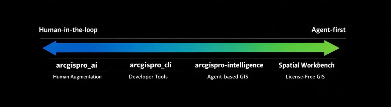
1. arcgispro_ai
Human-first augmentation
Repo: github.com/danmaps/arcgispro_ai
PyPI: pypi.org/project/arcgispro_ai
This is for Esri users working inside ArcGIS Pro who want to mix LLM capabilities into existing projects.
- Lives where analysts already work
- Assists with thinking, synthesis, explanation, and small automations
- AI is a collaborator, not the driver
- Designed to feel safe, inspectable, and reversible
Use this when a human is still the decision maker and ArcGIS Pro is the center of gravity.
2. arcgispro_cli
Developer-first workflows
Repo: github.com/danmaps/arcgispro_cli
PyPI: pypi.org/project/arcgispro-cli
This is for GIS developers who want modern AI coding tools to coexist with ArcGIS Pro workflows.
- Designed to pair with Claude Code, Codex CLI, Copilot CLI, Gemini CLI
- Treats ArcGIS Pro as an environment the agent can reason about
- Bridges traditional GIS tooling and modern AI-assisted development
- Optimized for iteration, scripting, and power users
Use this when the human is thinking in code and wants AI to accelerate implementation.
3. arcgispro-intelligence
Agent-first, Esri-aware
This is for situations where there is no human in the loop, but Esri data and conventions still matter.
- Opinionated, high-level GIS actions
- x402-style tools designed for agents, not UIs
- Focused on outcomes, not step-by-step geoprocessing
- Assumes planning, execution, and evaluation are automated
Use this when the agent owns the task and ArcGIS concepts are inputs, not constraints.
4. Spatial Workbench
Agent-first, license-free GIS
This is the logical extreme.
- No Esri license required
- Built on open tooling like Turf and Leaflet
- Designed for availability, quality, and composability
- The implementation details matter less than the results
Use this when scale, access, and automation matter more than vendor boundaries.
The unifying idea
This isn’t four products. It’s one philosophy applied at different points on the human to agent spectrum.
- Human insight first
- Developer leverage second
- Agent autonomy when appropriate
- Vendor optionality where possible
Quality and availability beat purity. The best tool is the one that can actually run, anywhere, by whoever or whatever needs it.